Inca Trail to Machu Picchu , Peru
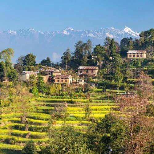
The Inca Trail is considered to be among the finest treks in the world because of its outstanding mix of sensational scenery and both interesting and fascinating cultural history. This famous route in Peru takes you over a beautiful section of the Andes Mountains, ending in the old city of Machu Picchu. From those who want an adventure-packed experience to those who want a proper historical trip, the Inca Trail can fulfill any type of traveler.
The classic Inca Trail covers about 26 miles (42 km) and usually takes 4 days to complete. Starting near Cusco, it reaches its highest point at Dead Woman’s Pass, which stands at around 13,828 feet (4,215 meters). The trek is considered moderate to challenging, as hikers need to be physically fit to manage the high altitude and steep paths.
The best time to visit the Inca Trail is during the dry season, from May to September when the skies are clearer and there’s less rain. However, temperatures can get cold at night. One should note that every February, the trail closes for maintenance.

Another experience awaiting hikers along the Inca Trail is the variation in ecosystem types, ranging from cloud forests to alpine tundra. With a historical backdrop, hikers will also pass by a few Incan ruins along the way. The view at the Sun Gate while ending the trek is truly breathtaking: offering a panoramic view of Machu Picchu.
Historically, the Inca Trail was part of the big Inca road system Qhapaq Ñan, which is more than 39,000 km long. The path leading to Machu Picchu can be the pilgrimage route to this sacred place of the Incas.
It is said that the very trail is an archaeological treasure, with a pretty big number of important Inca ruins: Llactapata, Runkurakay, Sayacmarca, Phuyupatamarca, and Winay Wayna. Once these centers had different functions from resting places to ceremonial and military ones.
Due to its popularity, access to the Inca Trail is limited. In other words, there are only a few permits available per day, and hikers must book with a licensed tour operator. A helpful tip is to book several months in advance, especially during peak season.
Annapurna Circuit Trek, Nepal
Nepal is renowned for its spectacular trekking routes, and the Annapurna Circuit Trek is one of the best hiking destinations in Asia. This trek is located in the Annapurna region of central Nepal, situated in the Himalayas. The trail stretches about 160-230 km (100-145 miles), depending on your starting and ending points. The highest point on the trek is Thorong La Pass, which reaches an elevation of 5,416 meters (17,769 feet) above sea level.
One of the main attractions of the Annapurna Circuit is crossing the challenging Thorong La Pass. Hikers will experience a range of landscapes, from lush subtropical forests to arid high-mountain terrain. The trek offers stunning views of towering peaks like Annapurna I and Dhaulagiri, and trekkers can immerse themselves in the cultures of traditional Nepali and Tibetan villages. Notable highlights include the dramatic Kali Gandaki Gorge, natural hot springs at Tatopani, and the sunrise view from Poon Hill, which provides panoramic vistas of the Annapurna and Dhaulagiri ranges.

The Annapurna Circuit is considered a moderate to challenging trek. It requires good physical fitness due to its length, altitude, and sometimes steep terrain, though it does not involve technical climbing skills. The high altitude, especially at Thorong La Pass, can be a challenge for some trekkers.
The best times to trek the Annapurna Circuit are from March to May (Spring) and September to November (Autumn). Spring offers warm temperatures and beautiful rhododendron blooms at lower elevations, while Autumn provides clear skies and stable weather, ideal for mountain views. These periods offer the most favorable weather conditions, though they are also the busiest times on the trail.
Lemosho Route , Kilimanjaro, Tanzania
The Lemosho Route in Mt. Kilimanjaro is arguably the most popular and rewarding trek to the highest peak in Africa and Tanzania in particular. Kilimanjaro lies in northern Tanzania, stretching 5,895 meters above sea level, and has been categorized as the tallest free-standing mountain anywhere in the world. Compared to the Coca-Cola and Whiskey Routes, Lemosho is getting more popular, while the summit success rate is higher. The longer route on Kilimanjaro makes it one of the easiest routes on Kilimanjaro, as it allows for better acclimatization and makes the climb more achievable.
The trek starts from the western side and takes the hikers through the rainforest to moorland and alpine desert landscapes. This route is also known for the beauty it offers, with an increasingly great chance of spotting wildlife at its early stages. Besides this, there are no technical climbing skills required on the Lemosho Route, although it is moderately challenging. The hikers must be physically fit and ready to face quite long trekking days at high altitudes. This is an excellent option; there's the added time for acclimatization should a person have a lot of fear regarding altitude sickness.

Tanzania’s two long dry seasons are from June to October, and December to early March is the best time to undertake the Lemosho Route treks. These are months when trekkers come across relatively safer and better weather since there is low rain and the skies are clear.
The hike takes about 7 to 8 days and some 70 km. Starting at Londorossi Gate, which is situated 2,100 meters above sea level, the tour proceeds gradually upwards toward Uhuru Peak, the summit of Kilimanjaro, standing at 5,895 meters. It means that during the hike tourists gain almost 3,800 meters of height and pass through quite a number of zones, adding both physical and landscape variety to the adventure.
The Jordan Trail, Jordan
The Jordan Trail is a long-distance hiking path through West Asia that covers complete Jordan, allowing outdoor enthusiasts to experience the country's rich history and natural beauty in an unforgettable way. Leading hikers through many of the most picturesque and scenic areas of the country as well as the historical landmarks, there is much reason to consider this among the premier hiking trails in the world. The trail begins from the northern town of Umm Qais to Aqaba in the south.

On the way, it passes through the different terrains of the Jordan Valley, the eastern desert, and the mountains around Petra and Wadi Rum. Varied landscapes found on this route offer perfect options for both novice and professional hikers alike. Some sections are more laborious than others. It should be considered that generally, the difficulty of the trail is moderate to hard because of its nature, weather, and length.
The best season to hike the Jordan Trail is in spring, which is March, April, and May, and the other is autumn, which includes September, October, and November. These periods offer milder temperatures that are ideal for hiking. These seasons are best suited for hikers, though summer can be very hot, especially in regions bordering the desert, while winter can be freezing, sometimes bringing snow even at higher altitudes.
Covering approximately 650 kilometers (404 miles), the trail’s elevation varies dramatically, from 400 meters below sea level near the Dead Sea to over 1,700 meters in the highlands. This range adds to the trail’s diverse and challenging nature.

The Jordan Trail’s highlights include some of Jordan’s most famous landmarks. Hikers can explore the ancient city of Petra, one of the New Seven Wonders of the World, and experience camping under the stars in the desert of Wadi Rum. The trail also passes through traditional Bedouin communities, offering a glimpse into local life and culture.
Other notable sites along the trail include the Roman ruins of Jerash, the mosaic-filled city of Madaba, and the Dana Biosphere Reserve, Jordan’s largest nature reserve. The journey concludes at the Red Sea in Aqaba, where hikers can celebrate their achievements with a swim.
The Great Trail, Canada
The Great Trail is the vast network of recreational trails across Canada. It connects all 13 provinces and territories, making it one of the finest hiking trails anywhere in the world. It extends from St. John's in Newfoundland in the east to Victoria in British Columbia in the west and extends north to Tuktoyaktuk in the Northwest Territories. The trail is both on land and water and is a route that offers great scenery with various beauties of Canada.
The Great Trail is widely described as the world's longest recreational trail, at approximately 24,000 kilometers, exceeding over 14,900 miles. Elevations can vary greatly between sea level along the coasts to over 2,000 meters in the Rocky Mountains.
The difficulty level of the great trail varies along the trail from easy urban paths to harder wilderness trails with a greater amount of hiking skills. All these make it the path suitable for people of all ages- from families taking a stroll to advanced backpackers looking for a great challenge.

The best time to explore the Great Trail depends on your personal preferences. Summer, from June to August, is the most popular time to hike the great trail, offering warm weather and long days. Spring and fall are also great for seeing wildflowers or enjoying the changing colors of the leaves. Large sections of it are good during winter for cross-country skiing, snowshoeing, biking, and canoeing.
Some of the Great Trail's main attractions are the rough coastlines of Newfoundland and Nova Scotia, Ontario's historic Rideau Canal, prairies of Saskatchewan and Manitoba, the Rocky Mountains of Alberta and British Columbia, and the Yukon and Northwest Territories virgin wilderness.
Hikers will also discover Canada’s rich culture. The trail passes through small towns, historic sites, and Indigenous lands. In cities, it offers a look at Canada’s lively communities, while in remote areas, hikers can see wildlife and enjoy nature.
The trail also has water routes, allowing for canoeing and kayaking on historic waterways like the Mackenzie River and the Great Lakes. This blend of land and water makes the trail unique, offering something for every outdoor lover.
Great Himalayan Trail, Nepal
The Great Himalayan Trail (GHT) is another popular trek in Nepal and is known as the longest and highest alpine hiking trail in the world. It spans the entire length of the Nepali Himalayas, from the eastern to the western parts of Nepal. The trek covers about 1,700 km (1,056 miles) and reaches its highest point at Sherpani Col, which is 6,146 meters (20,164 feet) above sea level. It is often regarded as the best long-distance hiking trail in the world.
Highlights of the GHT include breathtaking views of all the 8,000-meter peaks in Nepal. The trail takes trekkers through almost every major trekking region in the country. It features a wide range of landscapes, from tropical forests to high-altitude deserts. Along the way, trekkers experience rich cultural interactions with various ethnic groups and visit remote villages. The trek involves crossing high mountain passes like Sherpani Col, West Col, and Amphu Labsta, and includes visits to lesser-known areas such as Dolpo and Humla. Trekkers might also spot rare wildlife like snow leopards and red pandas. The GHT combines popular trekking routes with remote, rarely-visited trails.

The difficulty level of the GHT is extremely challenging. Completing the entire trek requires excellent physical fitness, previous high-altitude trekking experience, and sometimes technical mountaineering skills. Trekkers face long days at high altitudes, challenging terrain, and remote areas with limited facilities.
Explore Top Nepal Tour Packages:
Tour du Mont Blanc, France, Italy and Switzerland
The Tour du Mont Blanc (TMB) is one of Europe's most renowned hiking trails, and it's considered one of the best hikes around the world, encircling the Mont Blanc massif. Spanning about 165 kilometers (103 miles), it takes hikers through the scenic landscapes of France, Italy, and Switzerland. Along the trail, you'll witness stunning glaciers, alpine meadows, and towering mountain peaks, as well as travel through lush valleys and high mountain passes.
The highest point on the trail, Grand Col Ferret, sits at 2,584 meters (8,478 feet) and marks the border between Italy and Switzerland. While Chamonix, France, is the most common starting and ending point, hikers can begin the journey at other locations along the route.

The TMB is a moderately challenging hike. Although no technical climbing skills are required, it involves substantial daily elevation changes. Hikers should be prepared for long days on varied terrain, including steep inclines and descents. While the trail is well-maintained, certain sections can be rocky or exposed, demanding careful navigation.
The best time to hike the TMB is from mid-June to mid-September. July and August offer warmer temperatures, but early September is also ideal for fewer crowds and pleasant weather. Be mindful that some huts and facilities may close by mid-September.

Hikers typically complete the 170-kilometer (105-mile) trek in 7 to 11 days, depending on their pace. In addition to hiking, the TMB provides opportunities for wildlife spotting, scenic photography, and sampling local cuisines. Cultural experiences, such as staying in mountain huts and engaging with locals, add to the journey. Optional activities like paragliding and exploring nearby towns like Courmayeur and Chamonix further enhance the experience.
Everest Base Camp trek, Nepal
Located in the Khumbu region of northeastern Nepal, the Everest Base Camp trek covers approximately 130 km (80 miles) round trip. The highest point of the trek is Everest Base Camp itself, which sits at an elevation of 5,364 meters (17,598 feet) above sea level. For the best views of Mount Everest, trekkers can climb to Kala Patthar, which reaches 5,545 meters (18,192 feet). This iconic trek is often considered one of the top bucket list hikes for adventurers around the world.

Highlights of the trek include close-up views of Mount Everest and other major peaks such as Lhotse, Nuptse, Ama Dablam, and other peaks over 8,000 meters. Trekkers visit the actual Everest Base Camp used by climbers, experience the Sherpa culture in traditional villages like Namche Bazaar, and see Tengboche Monastery, the largest monastery in the Khumbu region. The trek also offers stunning sunrise views from Kala Patthar, the chance to cross suspension bridges over deep gorges and views of the Khumbu Glacier and Khumbu Icefall. Additionally, trekkers explore Sagarmatha National Park, a UNESCO World Heritage site.
The Everest Base Camp Trek is considered a moderate to challenging level. While it doesn’t require technical climbing skills, it demands good physical fitness due to the high altitude, long daily hikes, and sometimes steep terrain. Altitude sickness is a significant concern, so proper acclimatization is essential.

The best times to trek to Everest Base Camp are from March to May (Spring) and September to November (Autumn). Spring offers warmer temperatures and blooming rhododendrons at lower elevations, while Autumn provides clear skies and stable weather for excellent mountain views. These seasons offer the most favorable weather conditions, though they are also the busiest times on the trail.
Featured Trip:
Everest Base Camp Short Trek - 12 Days
Torres del Paine w Trek, Chile
The W Trek in Torres del Paine National Park, Patagonia, Chile, is one of the most well-known and scenic treks in South America. It offers stunning views of the Patagonian landscape, with turquoise lakes, glaciers, and subpolar forests along the way. Located in the southern part of Chilean Patagonia, the park is about 112 kilometers (70 miles) north of the town of Puerto Natales. The trail gets its name from its W-shaped route, which follows the foothills of the Paine Massif.
The best time to hike the W Trek is during the summer, from November to early April. December to February are the busiest months, as the weather is warmer and there are longer daylight hours. However, these months can also be windy and crowded. November and March-April are less busy but still offer good weather conditions. Winter treks, from May to September, are possible but require more experience due to harsh conditions.

The W Trek takes about 4 to 5 days to complete and covers a distance of around 80 kilometers (50 miles). The trail’s highest point reaches about 900 meters (2,950 feet), with daily hikes ranging between 15 and 20 kilometers (9 to 12 miles). The trek allows hikers to see wildlife like guanacos, foxes, and even pumas.
Hiking activities include trekking through diverse landscapes, taking photos of the natural scenery, and camping or staying in mountain refuges (huts). Some trekkers also take an optional boat trip on Grey Lake for a closer look at the glaciers, and stargazing is possible on clear nights.
The W Trek is known for its well-maintained infrastructure. Hikers can choose to camp or stay in refuges, providing some comfort during the trek. The trail can be done independently or with a guided group, offering flexibility for all kinds of trekkers.

While the W Trek doesn’t require technical climbing skills, it is still considered a moderate to challenging hike due to the long distances and varied terrain. Some parts of the trail are steep and rocky, so hikers should be in good shape and ready for unpredictable weather, which is common in Patagonia. The trail is well-marked, making it accessible for both experienced hikers and fit beginners, often regarded as one of the best hiking trails in the world for beginners.
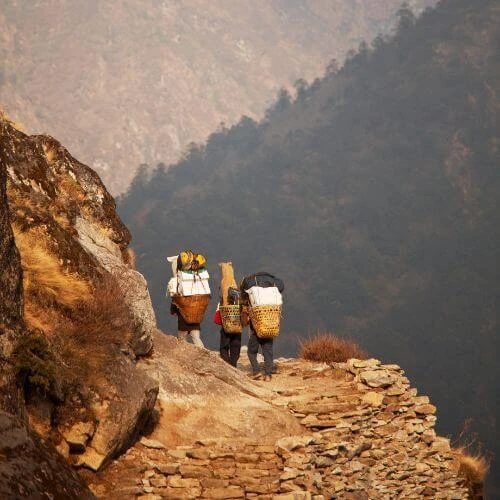
K2 base camp, Pakistan
The K2 Base Camp Trek is one of the most challenging yet rewarding adventures in the world. It takes hikers to the base of K2, the second-highest mountain on Earth, standing at 8,611 meters (28,251 feet). The trek is located in Pakistan's Gilgit-Baltistan region, and it leads through the Baltoro Glacier, one of the longest glaciers outside the polar regions, to K2 Base Camp, which sits at an elevation of 5,100 meters (16,896 feet).

This trek is known for its difficulty and is suitable only for experienced hikers who are in excellent physical condition. The terrain is tough, with rocky paths, glacier crossings, and the challenges of high altitude. Trekkers need to be prepared for long days of walking and potential altitude sickness, as the thin air at higher elevations can make the trek even harder.
The best time to trek to K2 Base Camp is between mid-June and early September. During this time, the weather is more stable, with clearer skies and milder temperatures. July and August are the most popular months, offering a good balance between warmer weather and lower chances of rain. However, weather in the Karakoram mountains can change quickly, so it's important to be prepared for sudden shifts in conditions.

The trek typically takes 14 to 21 days to complete and covers about 180 kilometers (112 miles). It starts in Askole, a village at 3,000 meters (9,843 feet), and reaches its highest point at Concordia, at 4,650 meters (15,256 feet), before arriving at K2 Base Camp. This journey is often regarded as one of the best multiday hikes for those seeking a challenging and breathtaking adventure.
In addition to the physical challenge, the K2 Base Camp Trek offers unique experiences. Trekkers can camp in beautiful, remote locations, cross glaciers, and take in incredible views of towering peaks. There are also opportunities to interact with international climbing teams at base camps and capture stunning photographs of the dramatic mountain environment. Acclimatization hikes to nearby viewpoints allow trekkers to take in even more of the spectacular scenery.
Gokyo Ri, Nepal
No doubt, Nepal has some of the most popular hiking destinations in the world, and Gokyo Ri is one of them. Gokyo Ri is a popular option for those looking to explore beyond the Everest Base Camp (EBC) trek in Nepal. It is located in the Khumbu region of northeastern Nepal, which is the same area as the EBC trek. The Gokyo Ri trek covers about 140-150 km (87-93 miles) round trip and reaches its highest point at Gokyo Ri, standing at 5,357 meters (17,575 feet) above sea level.

The trek offers stunning views of four of the world’s 8,000-meter peaks: Everest, Lhotse, Makalu, and Cho Oyu. Trekkers can also enjoy the beautiful turquoise Gokyo Lakes, which are the highest freshwater lakes in the world. The trek includes views of the Ngozumpa Glacier, the longest glacier in the Himalayas. Unlike the standard EBC route, the Gokyo Ri trek is less crowded. For those seeking more adventure, there’s the option to cross the challenging Cho La Pass (5,420m) if combined with the EBC trek. Similar to the EBC trek, trekkers will experience Sherpa culture and visit traditional villages. The landscapes vary from forests and alpine meadows to high-altitude terrain.
The difficulty level of the Gokyo Ri trek is moderate to challenging. It requires good physical fitness and proper acclimatization due to the high altitude. The trek to Gokyo Ri is steep and can be demanding.
Featured Trip:
Everest Three Passes Trek - 17 Days
Laugavegur Trail, Iceland
The Laugavegur Trail in Iceland is one of the world's most scenic hikes, offering a unique experience through Iceland's diverse and striking landscapes. This trek takes you through colorful rhyolite mountains, black sand deserts, and lush valleys, showcasing the incredible geology of the southern highlands of Iceland. This hike also offers the best opportunity to see the northern lights making it a must-visit hiking trail in the world.
The trail starts in the geothermal area of Landmannalaugar and ends in the glacial valley of Thorsmork. As you hike, you travel through the heart of Iceland’s remote wilderness, encountering a mix of flat sections, steep ascents, and descents. While the hike is not technically difficult, hikers need to be ready for long days of walking, variable terrain, and river crossings. Having good physical fitness and some hiking experience will help with the demands of the trail.

The best time to hike the Laugavegur Trail is between late June and early September when the weather is most favorable, and the snow has mostly melted. July and August are the most popular months, offering warmer temperatures and the chance to experience the midnight sun. However, even in summer, the weather can change quickly, so it's important to be prepared for rain, wind, and cold.
The trail is around 55 kilometers (34 miles) long and usually takes 3 to 4 days to complete. It ranges in elevation from about 500 meters (1,640 feet) to 1,100 meters (3,600 feet), with a total elevation gain of about 800 meters (2,600 feet). Along the way, hikers can camp or stay in mountain huts.

Aside from the hiking itself, the Laugavegur Trail offers other memorable experiences. You can relax in natural hot springs, photograph Iceland's stunning scenery, and see the effects of volcanic activity on the land. If you're hiking in late August or September, you might even catch a glimpse of the Northern Lights.
Milford Track, Newzeland
The Milford Track in New Zealand is often called one of the finest hikes in the world. Located in Fiordland National Park on the South Island, it is a famous hiking destination in the world that begins at Glade Wharf on Lake Te Anau and ends at Sandfly Point in Milford Sound. The area is known for its rugged beauty, with fjords, rainforests, and tall mountains. Hikers on the track can explore one of New Zealand's most untouched wilderness areas.
The Milford Track is 53.5 kilometers (33.2 miles) long and is considered moderate to challenging. The trail is well-maintained, but its length and the unpredictable weather can make it tough. Hikers should be in good shape since they will walk between 10 to 18 kilometers each day. The trail includes steep climbs, especially at Mackinnon Pass, which can be difficult.

Mackinnon Pass, the highest point of the track, reaches 1,154 meters (3,786 feet). The best time to hike the Milford Track is from late October to late April when the weather is more favorable. December to February are the warmest months, though these are also the busiest. November offers fewer crowds and spring flowers, while March and April bring cooler weather and autumn colors.
Some major highlights of the Milford Track include the Clinton River, Mackinnon Pass, and Sutherland Falls, one of New Zealand's highest waterfalls at 580 meters (1,904 feet). Hikers can also enjoy the unique native wildlife and Lake Ada
Ladakh Trek, India
The Ladakh Trek in India offers an incredible adventure through one of the most unique and beautiful regions in the country, often considered the best place to hike in India. Ladakh is situated in the northeastern portion of India, in the state of Jammu and Kashmir. Often called "Little Tibet," the area is known for its high-altitude deserts, rugged mountains, and ancient Buddhist monasteries.
Trekking in Ladakh can range from moderate to challenging, depending on the route you choose. The high altitude, with most of the region sitting above 3,000 meters, adds to the difficulty, making proper acclimatization essential. Trekkers need to be in good physical shape and ready for long days of walking in sometimes tough conditions.

The length and duration of treks in Ladakh vary. Some popular treks include the Markha Valley Trek, which takes 7 to 9 days and covers about 65 kilometers, and the Zanskar Trek, a more demanding route that lasts 14 to 20 days. For beginners, the Sham Valley Trek is a good option, taking 4 to 7 days.
Many of Ladakh's treks reach altitudes over 5,000 meters. For example, the Stok Kangri Trek peaks at 6,153 meters, while the Markha Valley Trek reaches 5,200 meters at Kongmaru La Pass. Due to these high altitudes, acclimatization is vital to avoid altitude sickness.
The best time to trek in Ladakh is from June to September when mountain passes are clear of snow and the weather is more stable. July and August offer the warmest temperatures, though this is also when Ladakh gets most of its rain, which is still minimal compared to other parts of India.
The highlights of trekking in Ladakh include the dramatic landscapes, where moon-like terrain meets lush valleys and snow-covered peaks. Trekkers can visit ancient Buddhist monasteries and experience the rich Buddhist culture that thrives in the region. You'll also have the chance to encounter traditional Ladakhi villages and meet the local people. Wildlife sightings are a bonus, with opportunities to spot rare animals like snow leopards, Tibetan wolves, and blue sheep.
Many treks in Ladakh involve crossing high mountain passes, providing breathtaking views and a sense of achievement. Camping in remote locations under the stars is a common part of the trekking experience, and some routes pass through the Changthang Plateau, home to nomadic communities.


 based on 15 reviews